ALERTCalifornia

Prepare · Respond · Recover

Developing Technology to Stay Ahead of Natural Disasters

ALERTCalifornia

Prepare · Respond · Recover

Developing Technology to Stay Ahead of Wildfires

Based at the University of California San Diego, ALERTCalifornia is a public safety program working to understand natural disasters and determine short and long-term impacts on people and the environment to inform management decisions.

ALERTCalifornia is a UC San Diego Program

VIEW LIVE CAMERA FEEDS

Cameras and sensors are deployed throughout California to monitor wildfires and disasters in real-time. 

camera-live-feed2

TESTIMONIALS

“It used to take 20 to 30 minutes for our fire ground commanders to get to fires and make decisions, and now with the cameras we are reacting within seconds of the first report… It’s making a difference. I can’t even put into words how important those first few minutes are.”
TONY MECHAM
CAL FIRE San Diego County Unit Chief
“Over the past two years, the ALERTCalifornia cameras in our unit have significantly improved the situational awareness of our response personnel on wildland fire calls throughout the unit.”
RICHARD SAMPSON
CAL FIRE Division Chief – Unit Forester
San Mateo-Santa Cruz Unit
"The cameras have been an invaluable resource for us, especially in areas where aviation weather reporting is unavailable, such as the rural regions we fly through. They have greatly aided us in making safe decisions regarding weather conditions, allowing us to transport our patients safely. Just this morning, in fact, we were able to utilize the cameras to show us a massive fog bank that is not showing up on the weather stations available to us."
MARQUIS LUTGE
FP-C Flight Paramedic, Base Safety Rep

LIVE MAP

CAMERA FEEDS

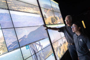
ALERTCalifornia has more than 1,144 high-definition, pan-tilt-zoom cameras deployed across California (as of January 2025), providing a 24-hour backcountry network with near-infrared night vision to monitor disasters such as active wildfires. ALERTCalifornia cameras can perform 360-degree sweeps approximately every two minutes and can view as far as 60 miles on a clear day and 120 miles on a clear night. Explore our “camera quilt” to view live camera feeds and for more details on camera and network status.

LOCATIONS

INSTALLATIONS

ALERTCalifornia has an extensive, ever-expanding camera network in California. Researchers at UC San Diego have taken the lead in creating the cyberinfrastructure to process, store, manage and visualize the massive amounts of incoming data from these camera installations. Our discoveries help mitigate the impact of wildfires on people and property, and bolster research into how to best prepare and respond to wildfire threats, both before, during and after serious burn events. 

ALERTCalifornia

TECHNOLOGY

As the ALERTCalifornia camera network and cyberinfrastructure grow in size and sophistication, UC San Diego researchers are using cutting-edge technology to gain insight into changing natural disaster patterns in the West. ALERTCalifornia provides state-of-the-art technology that supports data-driven decisions to prepare for, respond to, and recover from natural disasters.

THE LATEST FROM ALERTCalifornia

Instagram

The ALERTCalifornia Las Virgenes camera is closest to the #KennethFire and is helping to monitor the incident along with other cameras throughout the LA region. See the current view live by searching the camera name on our site linked in bio. 

Be sure to get reputable updates from the Los Angeles County Fire Department and CAL FIRE at their incidents page fire.ca.gov/incidents
298 1
The #EatonFire is reaching the peak of Mt. Wilson as seen from ALERTCalifornia's Pine Mountain LA 1 camera. Watch conditions live by searching the camera name on our site linked in bio. Look to Los Angeles County Fire Department and CAL FIRE for updates.
378 1
The #SunsetFire recently ignited in the Hollywood Hills above downtown Los Angeles, which can be seen in the background. Watch conditions live on ALERTCalifornia's Mt. Lee S camera by searching the camera name on our site linked in bio. Look to Los Angeles Fire Department and CAL FIRE for official updates.
418 3
The Cameras.ALERTCalifornia.org site is the fastest available tool for the general public to see live camera views. It is also mobile friendly and designed for public use. #PalisadesFire #EatonFire #HurstFire
434 2
Intense imagery is being captured across ALERTCalifornia's camera network as multiple major fires burn across Southern California. This clip from the #PalisadesFire is from The ALERTCalifornia Temescal Trailhead camera and shows the intense wind and blowing cinders. See all cameras live 24/7 at cameras.alertcalifornia.org.
508 8
Sunset over the #PalisadesFire in Los Angeles County captured by the Wilshire 2 ALERTCalifornia camera in Santa Monica. Look to the Los Angeles Fire Department for updates and evacuation information and see conditions live on our camera site linked in bio.
195 1
Helicopters refill their tanks to fight the #PalisadesFire in Los Angeles County captured on ALERTCalifornia's LACFD Helibase 69 Bravo East camera. Look to Los Angeles County Fire Department for updates and check the latest on cameras linked in our bio.
215 0
Start and growth of the #PalisadesFire in LA County on the morning of Jan. 7 captured on the ALERTCalifornia Wilshire 2 camera.  Look to Los Angeles County Fire for updates and see conditions live from multiple cameras at our site linked in bio.
415 3
Thanks for another great year. ALERTCalifornia is rounding off 2024 with more than 1,040 cameras across the state. Looking forward to supporting emergency managers, state and local governments, and the public with our research and camera sensor network into 2025 and beyond.
85 0
Coming in hot! Can anyone help us ID this bird of prey swooping in to land near the Lebec Oaks 1 camera? #firecambirds
105 4

VIDEO

TWITTER

Load More

Neal Driscoll

Principal Investigator

Dr. Neal Driscoll is the principal investigator of the ALERTCalifornia program at the University of California San Diego, where he is a professor of geology and geophysics at Scripps Institution of Oceanography.

Driscoll’s background in natural hazard research traces back more than 35 years. He has published more than 120 manuscripts in high impact peer-reviewed journals, including Science, Nature Geoscience, Geology, and the Journal of Geophysical Research on subjects ranging from earthquake hazards to devastating wildfires., He has received multiple awards during his career, including the Heezen and Storke Awards for excellence in research and UC San Diego’s inaugural Undergraduate Teaching Award. Driscoll has also appeared in articles published by The Associated Press, The New York Times, CBS News, The Los Angeles Times, KGTV, KPBS and other notable news outlets.

Driscoll received his Ph.D. in geology and geophysics from Columbia University and worked as an associate research scientist at the Woods Hole Oceanographic Institution in Falmouth, MA before joining UC San Diego in 2000. His research interests at Scripps Oceanography include landscape and seascape evolution in response to tectonic deformation, sea-level fluctuations, climate, neotectonics, and geohazards.